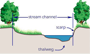
thalweg
推荐文章
n. 海谷底线,海谷深泓线;最深谷底线
n.
最深谷底线;深泓;深泓线;
英英释义
thalweg[ 'tɑ:lveɡ ]
n.
the middle of the chief navigable channel of a waterway that forms the boundary line between states
a line following the lowest points of a valley
权威例句
Thalweg or talwegTHALWEG OR TALWEGThalweg or talweg
Thalweg in Loess Hill Area Based on DEM
Extraction of thalweg networks from DTMs: application to badlands
Using thalweg profiling to assess and monitor juvenile salmon (Oncorhy...
Thalweg variability at bridges along a large karst river: the Suwannee River, Florida
Nitrogen cycling and metabolism in the thalweg of a prairie river
Threshold conditions for thalweg gullying with special reference to loess areas.
Temporal and spatial variability in thalweg profiles of a gravel‐bed river
Rill erosion along the thalweg of a hillslope hollow: A case study from the cotswold hills, Central England
thalweg (n.)
1831, from German Thalweg "path along the bottom of a valley," from thal (see dale) + weg (see way).
1. The study shows that the technology and method of distilling the thalweg using DEM are practical and effective.
实验结果证明,利用DEM自动提取沟沿线是一种快速、有效的技术方法。
dict.cnki.net
2. The thalweg in loess hill area is an important terrain structural line, reflecting topography and landform character.
黄土丘陵区的沟沿线,是反映该区地形地貌特征的重要的地形结构线。
dict.cnki.net
3. With quantitative thalweg evolution analysis in rivers coordinate system, the accurate thalweg of planar and vertical displacement of erosion and deposition can be calculated.
在河流坐标系中进行定量的深泓线演变分析,可精确计算深泓线的平面位移和垂向冲淤。
www.fabiao.net
4. The effects of permeable pile groynes laid out along the thalweg in control and guide the regime of the lower Yellow River have been studied through movable bed model tests.
通过河工动床模型试验,对沿治导线布设形式的透水桩坝在黄河下游控导河势的效果进行了研究。
dict.cnki.net
5. Raster DEM grid search method is to obtain the riverbed thalweg through a two-dimensional matrix search with a certain height rules.
栅格DEM搜索法是通过二维高程矩阵按照一定规则进行搜索,获取河床深泓线;
www.fabiao.net
6. Raster DEM grid search method is to obtain the riverbed thalweg through a two-dimensional matrix search with a certain height rules.
栅格DEM搜索法是通过二维高程矩阵按照一定规则进行搜索,获取河床深泓线;
www.fabiao.net